This morning was the first morning this winter when drivers awake to potentially icy roads. The first areas to usually ice over are bridges and high elevation areas. Well, as it turns out I-565 through downtown Huntsville and, by extension, US 72 over Chapman Mountain features both types of hazards. As a result, this stretch of road is often closed when there is snow, ice, or both.
Here is a scenario for you. You live in Memphis and you are trying to get to Chattanooga. Part of your route involves taking I-565 through Huntsville to reach US 72 east. However, when you arrive in Huntsville at 6 AM in the morning, there is a portable message sign in front of the Space and Rocket Center saying that I-565 is closed ahead and all traffic must exit at Exit 17B. The elevated portion of I-565 has been closed due to icy conditions. So you exit at Exit 17B. Where you go from here?
Exit 17B is Governors Drive which used to be the main route into Huntsville before I-565 was constructed. This is the last exit that you encounter before the notorious elevated portion of I-565 begins. Once you are dumped onto Governors Drive, however, there is no signage directing you from there. You have to know where to go. A GPS won’t help you here; it doesn’t know the best way around if I-565 is closed. You either have to know your way around Huntsville, or you are lost.
If you are going west on I-565 or US 72 at Moores Mill Rd, you are dumped onto either Moores Mill Rd or Andrew Jackson Way/Oakwood Ave, depending on whether US 72 over Chapman Mountain is closed. Again, once you are dumped onto the local streets, there are no signs guiding you back to I-565 west of the elevated sections. This is the case if you are going from, let’s say, Chattanooga to Memphis.
Firstly, I am going to propose a very simple solution to this problem of lack of signage. ALDOT may already be implementing this solution (or it is a sign goof), but I would suggest placing “ALTERNATE I-565/US 72” or “DETOUR I-565/US 72”signs along suggested routes to get around the elevated sections of I-565 and US 72 over Chapman Mountain. Here is a picture of a sign I saw in Huntsville a week ago:

The signs I would post throughout the alternate routings would look just like the one above (without the US 231/431 signs), but it would also have a US 72 sign below it as well since it may also be involved in the closure.
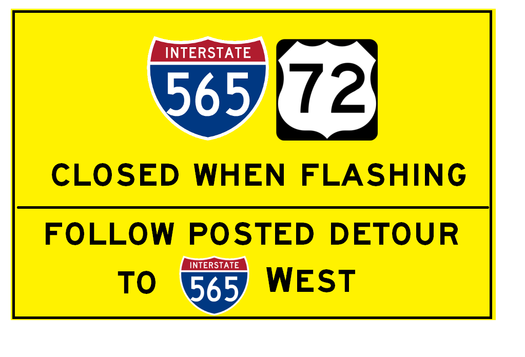
I would erect signs such as these, along with two flashing yellow beacons at the top, to inform drivers to follow the posted route if I-565 is closed:
I would place one before Research Park Blvd and another one in front of the Space and Rocket Center going eastbound on I-565, and then one just west of Dug Hill Rd and just east of Shields Rd on US 72 west.
Now I am sure you are asking: what alternate routing would you suggest if I-565 is closed? Here is my preferred alternative routing:

The route going eastbound would be Exit 17B, AL 53 South/Governors Drive to US 231/431 North/Memorial Pkwy to Winchester Road east to Moores Mill Rd South to US 72 east. This route works well since all of it is four-lanes. There are two issues with this route. One is the intersection of Moores Mill Rd and Winchester Rd. Large 18-wheelers may have difficulty making the turn from northbound Moores Mill Rd to westbound Winchester Rd. Alternatives to this intersection would involve taking streets not designed for truck traffic. This intersection has been recently modified as a result of the widening of Winchester Rd.
The other issue arises with Memorial Pkwy. It also has elevated sections. Typically, I-565 gets closed first, but there are also cases when the overpasses along Memorial Parkway also close. This isn’t as bad as I-565 closing since traffic is simply diverted onto the frontage roads, but it can be slow-going along the frontage roads since the traffic signals don’t have an override signal phasing plan that I know if if the overpasses along the parkway are closed. This could be alleviated by police directing traffic at these intersections or programming a separate signal phasing plan for when the overpasses are closed that would favor traffic continuing along the frontage roads. You could also take other routes, but you may spend as much time on the other routes as you would on this main alternate routing.
Other routes that may be worth considering may use Meridian Street, Oakwood Ave, Andrew Jackson Way, and/or California Street, in addition to the route described above.
In the distant future, however, this may not be as big of a problem if the northern bypass of Huntsville is completed to US 72 east. That would provide the best bypass of both Chapman Mountain and the elevated portions of I-565, but we still have a long way to go before that comes to fruition.
Here is a scenario for you. You live in Memphis and you are trying to get to Chattanooga. Part of your route involves taking I-565 through Huntsville to reach US 72 east. However, when you arrive in Huntsville at 6 AM in the morning, there is a portable message sign in front of the Space and Rocket Center saying that I-565 is closed ahead and all traffic must exit at Exit 17B. The elevated portion of I-565 has been closed due to icy conditions. So you exit at Exit 17B. Where you go from here?
Exit 17B is Governors Drive which used to be the main route into Huntsville before I-565 was constructed. This is the last exit that you encounter before the notorious elevated portion of I-565 begins. Once you are dumped onto Governors Drive, however, there is no signage directing you from there. You have to know where to go. A GPS won’t help you here; it doesn’t know the best way around if I-565 is closed. You either have to know your way around Huntsville, or you are lost.
If you are going west on I-565 or US 72 at Moores Mill Rd, you are dumped onto either Moores Mill Rd or Andrew Jackson Way/Oakwood Ave, depending on whether US 72 over Chapman Mountain is closed. Again, once you are dumped onto the local streets, there are no signs guiding you back to I-565 west of the elevated sections. This is the case if you are going from, let’s say, Chattanooga to Memphis.
Firstly, I am going to propose a very simple solution to this problem of lack of signage. ALDOT may already be implementing this solution (or it is a sign goof), but I would suggest placing “ALTERNATE I-565/US 72” or “DETOUR I-565/US 72”signs along suggested routes to get around the elevated sections of I-565 and US 72 over Chapman Mountain. Here is a picture of a sign I saw in Huntsville a week ago:
Figure 1: A I-565 ALTERNATE sign was posted recently in Huntsville. Is this part of an alternate routing in case I-565 is closed, or a sign error?
The signs I would post throughout the alternate routings would look just like the one above (without the US 231/431 signs), but it would also have a US 72 sign below it as well since it may also be involved in the closure.
I would erect signs such as these, along with two flashing yellow beacons at the top, to inform drivers to follow the posted route if I-565 is closed:
Figure 2: An example of a sign I would erect on US 72 westbound
I would place one before Research Park Blvd and another one in front of the Space and Rocket Center going eastbound on I-565, and then one just west of Dug Hill Rd and just east of Shields Rd on US 72 west.
Now I am sure you are asking: what alternate routing would you suggest if I-565 is closed? Here is my preferred alternative routing:
The route going eastbound would be Exit 17B, AL 53 South/Governors Drive to US 231/431 North/Memorial Pkwy to Winchester Road east to Moores Mill Rd South to US 72 east. This route works well since all of it is four-lanes. There are two issues with this route. One is the intersection of Moores Mill Rd and Winchester Rd. Large 18-wheelers may have difficulty making the turn from northbound Moores Mill Rd to westbound Winchester Rd. Alternatives to this intersection would involve taking streets not designed for truck traffic. This intersection has been recently modified as a result of the widening of Winchester Rd.
The other issue arises with Memorial Pkwy. It also has elevated sections. Typically, I-565 gets closed first, but there are also cases when the overpasses along Memorial Parkway also close. This isn’t as bad as I-565 closing since traffic is simply diverted onto the frontage roads, but it can be slow-going along the frontage roads since the traffic signals don’t have an override signal phasing plan that I know if if the overpasses along the parkway are closed. This could be alleviated by police directing traffic at these intersections or programming a separate signal phasing plan for when the overpasses are closed that would favor traffic continuing along the frontage roads. You could also take other routes, but you may spend as much time on the other routes as you would on this main alternate routing.
Other routes that may be worth considering may use Meridian Street, Oakwood Ave, Andrew Jackson Way, and/or California Street, in addition to the route described above.
In the distant future, however, this may not be as big of a problem if the northern bypass of Huntsville is completed to US 72 east. That would provide the best bypass of both Chapman Mountain and the elevated portions of I-565, but we still have a long way to go before that comes to fruition.
Nice post, Cody. Posting alternates is always a good way to go. So, where exactly is Chapman Mountain? Is that just east of I-565's eastern end?
ReplyDeleteAdditionally, how goes that frontage road work on Memorial Parkway?
As for Chapman Mountain, you are correct. It is the mountain you ascent at I-565's eastern end where US 72 picks up.
ReplyDeleteAs for the Memorial Parkway work (I assume you are talking about between Oakwood Avenue and Mastin Lake Rd) it is almost finished. The bridges are done save for some of the guardrails. The main lanes just need a couple more layers of asphalt and it should be ready for traffic to roll on them.