Huntsville, Decatur, Athens, and the surrounding area is a spread-out area. Having a car is a must to get around. I believe that transit is certainly an option for the Tennessee Valley, but it will take a lot of careful planning as well as a willingness of people to use it for it to take off.
While the perfect transit system would encompass our entire area from Decatur in the west to Chase in the east and all points in between, we have to start small. It would also use different modes of transit: light rail, buses, bike lanes, and multi-use paths.
The starting point for a transit system could come in the form of a light rail system in Research Park. A lot of people frequent the areas surrounding research park for lunch and for other errands:

The Redstone Gateway development is also being constructed south of I-565 around Gate 9 which will contain both offices and restaurants.
As you can see, a lot of the restaurants are concentrated along University Drive (US 72) and there are some along Old Madison Pike east and west of Research Park Blvd. Most of the offices are in between those concentrations of commercial areas. There are also people coming from the south via Research Park Blvd (which becomes Rideout Rd south of I-565) from Redstone Arsenal to go to these same restaurants as well.
The major routes coming into Research Park are Old Madison Pike which serves the southern end of the park, Bradford Blvd from the east, Enterprise way from the north, Farrow Rd from the west, and Research Park Blvd from the north and south. Wynn Drive serves the eastern edge of the park, and University Drive skirts the north side of Research Park but doesn’t actually enter it.
The roads inside research park lend themselves quite well to light rail due to the fact that there is a median:

It would be easy to establish a light rail line in the median of the roads in research park. My proposal for light rail routes utilizing the median of the roads would look like this:
Note that the western end of Old Madison Pike is in the planning phase of widening. It will probably include a median. It should be built wide enough to accommodate light rail when the system is built out.
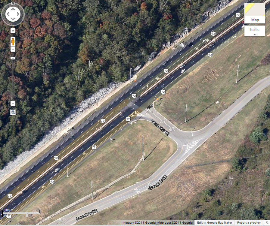
This would be the core of the light rail system in Research Park. Stops can be in the median with pedestrian access from either side. The stops may require the median to be widened so that the station can be fit completely within the median. Intersections of light rail lines would take up room within the intersection of the roadways (such as at Bradford and Explorer Blvd). Light rail train signaling would have to be coordinated with the traffic signals in place for vehicles.
Another option could be to have two light rail lines (one in each direction) built in the car lanes themselves. However, I could see this working less efficiently due to the mixing of cars and trains in the same space.
The light rail line along Old Madison Pike can be extended east inside the center turn lane from Bridge Street east, but this would require the Old Madison Pike bridge over Research Park Blvd to be widened. Even though the light rail line would run in the center turn lane, cars can still use the lane when a train is not coming. Here is an example from Memphis:
Another solution would be to simply close off the center lane and only allow turns from the inside lane from either direction. Putting a station along here would be accomplished by putting the station on the side of the road like a bus stop. When the train stops, people cross the road to get on the train, and a traffic signal could be put at the station to stop traffic in either direction.
This system works well and good, but we need a way to build a light rail line along University Drive. Putting a light rail line in the median would be impractical because it would require pedestrians to cross busy University Drive, and there is also less room to put in a line in the median of University Drive since there is less of a median in which to put it. One option is to put a line directly south of University Drive on dedicated right of way. This may eat up some parking areas along University. Taking the light rail line under Research Park Blvd would be an expensive proposition. It would be best to curve it away from University at the interchange with Research Park Blvd and take it below grade to pass under Research Park Blvd. The light rail line would extend east to Wynn Drive.

Note that this system isn’t all of the ideas I have for a transit system for Huntsville. It can be, and should be, built out farther. I have ideas to build light rail or commuter rail along the Norfolk Southern rail line between Decatur and Huntsville as well as the Huntsville-Madison County Rail Authority track that runs parallel to Memorial Pkwy. A better bus system and park and ride lots will also be needed in order to make this successful. I think that this would be a good start, and it is a system that can be used during the day to get from work to lunch.
While the perfect transit system would encompass our entire area from Decatur in the west to Chase in the east and all points in between, we have to start small. It would also use different modes of transit: light rail, buses, bike lanes, and multi-use paths.
The starting point for a transit system could come in the form of a light rail system in Research Park. A lot of people frequent the areas surrounding research park for lunch and for other errands:
Figure 1: Research Park in Huntsville and proximity of restaurants and other commercial areas
The Redstone Gateway development is also being constructed south of I-565 around Gate 9 which will contain both offices and restaurants.
As you can see, a lot of the restaurants are concentrated along University Drive (US 72) and there are some along Old Madison Pike east and west of Research Park Blvd. Most of the offices are in between those concentrations of commercial areas. There are also people coming from the south via Research Park Blvd (which becomes Rideout Rd south of I-565) from Redstone Arsenal to go to these same restaurants as well.
The major routes coming into Research Park are Old Madison Pike which serves the southern end of the park, Bradford Blvd from the east, Enterprise way from the north, Farrow Rd from the west, and Research Park Blvd from the north and south. Wynn Drive serves the eastern edge of the park, and University Drive skirts the north side of Research Park but doesn’t actually enter it.
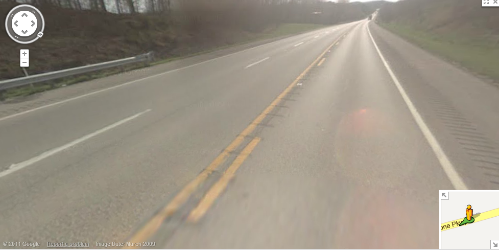
The roads inside research park lend themselves quite well to light rail due to the fact that there is a median:
Figure 2: Explorer Blvd in Research Park, courtesy of Google Street View
It would be easy to establish a light rail line in the median of the roads in research park. My proposal for light rail routes utilizing the median of the roads would look like this:
Figure 3: Light rail routes utilizing existing median space
Note that the western end of Old Madison Pike is in the planning phase of widening. It will probably include a median. It should be built wide enough to accommodate light rail when the system is built out.
This would be the core of the light rail system in Research Park. Stops can be in the median with pedestrian access from either side. The stops may require the median to be widened so that the station can be fit completely within the median. Intersections of light rail lines would take up room within the intersection of the roadways (such as at Bradford and Explorer Blvd). Light rail train signaling would have to be coordinated with the traffic signals in place for vehicles.
Another option could be to have two light rail lines (one in each direction) built in the car lanes themselves. However, I could see this working less efficiently due to the mixing of cars and trains in the same space.
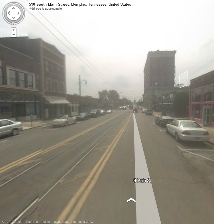
The light rail line along Old Madison Pike can be extended east inside the center turn lane from Bridge Street east, but this would require the Old Madison Pike bridge over Research Park Blvd to be widened. Even though the light rail line would run in the center turn lane, cars can still use the lane when a train is not coming. Here is an example from Memphis:
Figure 4: Light rail/trolley in center of road in Memphis
Another solution would be to simply close off the center lane and only allow turns from the inside lane from either direction. Putting a station along here would be accomplished by putting the station on the side of the road like a bus stop. When the train stops, people cross the road to get on the train, and a traffic signal could be put at the station to stop traffic in either direction.
This system works well and good, but we need a way to build a light rail line along University Drive. Putting a light rail line in the median would be impractical because it would require pedestrians to cross busy University Drive, and there is also less room to put in a line in the median of University Drive since there is less of a median in which to put it. One option is to put a line directly south of University Drive on dedicated right of way. This may eat up some parking areas along University. Taking the light rail line under Research Park Blvd would be an expensive proposition. It would be best to curve it away from University at the interchange with Research Park Blvd and take it below grade to pass under Research Park Blvd. The light rail line would extend east to Wynn Drive.
Figure 5: Light rail along University Drive west of Research Park Blvd
Note that this system isn’t all of the ideas I have for a transit system for Huntsville. It can be, and should be, built out farther. I have ideas to build light rail or commuter rail along the Norfolk Southern rail line between Decatur and Huntsville as well as the Huntsville-Madison County Rail Authority track that runs parallel to Memorial Pkwy. A better bus system and park and ride lots will also be needed in order to make this successful. I think that this would be a good start, and it is a system that can be used during the day to get from work to lunch.