For everyday commuters, guide signs are just a blur as one comes into work everyday. However, if you are a tourist or are new to the area, guide signs can be a lifesaver when trying to find your way around. These signs point out the name of the road you are on, but can also tell you what exit you are coming up on, how many miles you are to the next destination, or what direction to go to reach a destination. Generally, any sign that is green can be classified as a guide sign.
I am goign to talk about three problems with guide signage in Huntsville: how to handle road name changes, how to sign roads that have both a number and a name, and better signage of surrounding cities
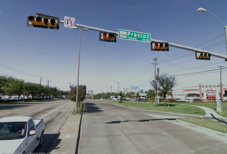
Huntsville for the most part does really well with guide signage. However, you could be driving along a road and you know you are on Airport Road. Then all of a sudden, the road name changes to Carl T. Jones Rd. Or, you are looking for Carl T. Jones Rd but you don’t know how to get to it. Airport Rd is the most obvious example of a road where the name changes several times:

There are other roads just in the city of Huntsville that change names like this:
-Jeff Rd/Slaughter Rd
-Sparkman Dr/Bob Wallace Ave/US 72 east
-Old US 431/Sutton Rd/Cecil Ashburn Drive/Four Mile Post Rd
-Governors Drive/US 431 South
-US 72 West/University Drive/Pratt Ave/Bankhead Pkwy
-Memorial Pkwy/US 231/431 Hwy
-Patton Rd/Jordan Lane/Highway 53
Then in Madison you have Wall Triana Hwy, which changes to Sullivan Street once you approach downtown Madison, then once you leave downtown Madison it changes back to Wall Triana Hwy.
When driving on these roads there is little to no warning when the name changes. This can get confusing if you are trying to find an address without a GPS. There are some instances where the name change is signed with a small green sign, but the sign is small and easy to miss:

I would prefer to see a large sign that says, for example, (END Airport Rd / BEGIN Carl T. Jones Rd) every time the street name changes. It should be as large as signs on the interstates so that it is hard to miss.

On a related topic, the state maintained routes have numbers assigned to them in addition to names, in some cases. Here is a list of roads that have overlapping numbers and names in Huntsville
In a lot of cases, the name and number are used interchangeably, which can lead to confusion. I have a simple solution to this problem. Provide both the street name and route number shield (if applicable) on a guide sign if it is attached to a traffic signal installation. I like how the city of Dallas, TX handles this:
Underneath overpasses on interstate highways in Alabama, there are already signs that are similar to these. Here is an example from Huntsville:
Here is an example of what I would do for the Huntsville signs on traffic signals:

Another problem I have noticed is that there is little no signs telling you what towns or cities you can reach by taking a certain road out of town. No sign tells you that Fayetteville, TN can be reached by taking US 231/431; there is little to no signs that say that US 431 south goes to Guntersville or that Highway 53 goes to Ardmore (and to Nashville) or that US 72 east goes to Chattanooga (Scottsboro is mentioned, but nothing besides that), or that US 231 south/Memorial Pkwy goes to Arab.
The solution here is simple: provide a mileage sign after every major intersection or interchange that says how far it is to the next city, town, or large destination. My preference would be:
If we use US 72 east as an example, one would arrive at a sign such as this after passing through the Shields Rd intersection:

In urban areas, it is also often helpful to post distances to the next major street on these signs as well. This would be especially helpful on US 231/Memorial Pkwy. Sometimes, this is combined with the next city destination as well. Here is an example of one such sign I would place on Memorial Pkwy southbound after the Governors Drive exit:

Even though in this case the next exit would actually be Bob Wallace Avenue, one would encounter that exit immediately after crossing over the top of Governors Drive. Therefore, I have excluded that street from the sign above.
I have other ideas for better guide signs in Huntsville, but this is enough to get to conversation going. Let me know if you have any ideas! Hopefully with better signs, people can get around more easily, and the chances of wrecks will decrease as a result.
I am goign to talk about three problems with guide signage in Huntsville: how to handle road name changes, how to sign roads that have both a number and a name, and better signage of surrounding cities
Huntsville for the most part does really well with guide signage. However, you could be driving along a road and you know you are on Airport Road. Then all of a sudden, the road name changes to Carl T. Jones Rd. Or, you are looking for Carl T. Jones Rd but you don’t know how to get to it. Airport Rd is the most obvious example of a road where the name changes several times:
Figure 1: Name changes for “Airport Road.” From northwest to southeast: Johnson Road (Red), Airport Road (Blue), Carl T. Jones (Green), Bailey Cove Rd (Pink), Green Cove Rd (Purple)
There are other roads just in the city of Huntsville that change names like this:
-Jeff Rd/Slaughter Rd
-Sparkman Dr/Bob Wallace Ave/US 72 east
-Old US 431/Sutton Rd/Cecil Ashburn Drive/Four Mile Post Rd
-Governors Drive/US 431 South
-US 72 West/University Drive/Pratt Ave/Bankhead Pkwy
-Memorial Pkwy/US 231/431 Hwy
-Patton Rd/Jordan Lane/Highway 53
Then in Madison you have Wall Triana Hwy, which changes to Sullivan Street once you approach downtown Madison, then once you leave downtown Madison it changes back to Wall Triana Hwy.
When driving on these roads there is little to no warning when the name changes. This can get confusing if you are trying to find an address without a GPS. There are some instances where the name change is signed with a small green sign, but the sign is small and easy to miss:
Figure 2: Courtesy of Google Street View: small sign says “End James Record Rd; Begin Martin Rd” near the Huntsville International Airport
I would prefer to see a large sign that says, for example, (END Airport Rd / BEGIN Carl T. Jones Rd) every time the street name changes. It should be as large as signs on the interstates so that it is hard to miss.
Figure 3: Example of big green sign (BGS) to signify road name change
On a related topic, the state maintained routes have numbers assigned to them in addition to names, in some cases. Here is a list of roads that have overlapping numbers and names in Huntsville
- US 431 (Governors Drive)
- AL 53 (Governors Drive)
- AL 53 (Jordan Lane)
- US 72 (University Drive)
- AL 255 (Research Park Blvd)
- AL 255 (Dr. Martin Luther King Jr. Blvd)
- US 231 (Memorial Pkwy)
- US 231/431 (Memorial Pkwy)
In a lot of cases, the name and number are used interchangeably, which can lead to confusion. I have a simple solution to this problem. Provide both the street name and route number shield (if applicable) on a guide sign if it is attached to a traffic signal installation. I like how the city of Dallas, TX handles this:
Figure 4: How Dallas, TX handles street names that also have route numbers
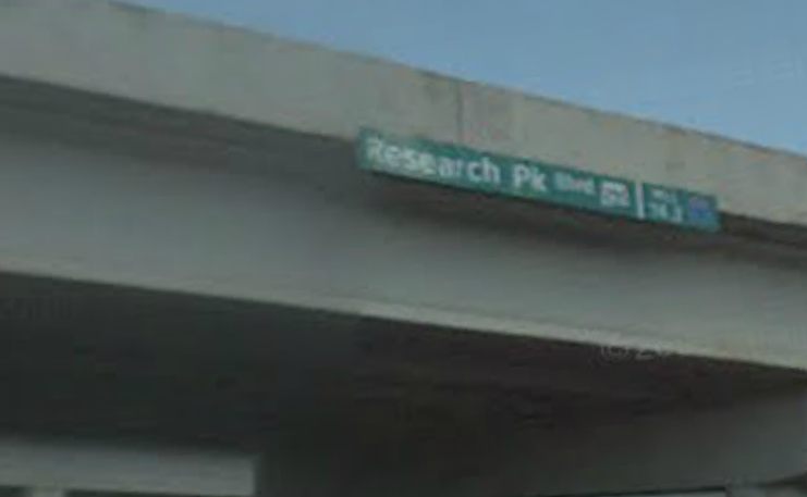
Underneath overpasses on interstate highways in Alabama, there are already signs that are similar to these. Here is an example from Huntsville:
Figure 4: Research Park Blvd (AL 255) overpass guide sign along I-565 in Huntsville
Here is an example of what I would do for the Huntsville signs on traffic signals:
Figure 5: An example of how to do street name signs with both route numbers and names in Huntsville, AL
Another problem I have noticed is that there is little no signs telling you what towns or cities you can reach by taking a certain road out of town. No sign tells you that Fayetteville, TN can be reached by taking US 231/431; there is little to no signs that say that US 431 south goes to Guntersville or that Highway 53 goes to Ardmore (and to Nashville) or that US 72 east goes to Chattanooga (Scottsboro is mentioned, but nothing besides that), or that US 231 south/Memorial Pkwy goes to Arab.
The solution here is simple: provide a mileage sign after every major intersection or interchange that says how far it is to the next city, town, or large destination. My preference would be:
- Distance to next town
- Distance to next sizable city
- Distance to next major city
If we use US 72 east as an example, one would arrive at a sign such as this after passing through the Shields Rd intersection:
Figure 6: Hypothetical mileage sign for US 72 east after the Shields Rd intersection
In urban areas, it is also often helpful to post distances to the next major street on these signs as well. This would be especially helpful on US 231/Memorial Pkwy. Sometimes, this is combined with the next city destination as well. Here is an example of one such sign I would place on Memorial Pkwy southbound after the Governors Drive exit:
Figure 7: Hypothetical street mileage sign immediately south of the Governors Drive exit
Even though in this case the next exit would actually be Bob Wallace Avenue, one would encounter that exit immediately after crossing over the top of Governors Drive. Therefore, I have excluded that street from the sign above.
I have other ideas for better guide signs in Huntsville, but this is enough to get to conversation going. Let me know if you have any ideas! Hopefully with better signs, people can get around more easily, and the chances of wrecks will decrease as a result.
I've noticed that road sign names are just not that big. If I was looking to turn onto Jeff Road, I wouldn't know until I was crossing it on 72 and by then it'd be too late. I don't understand why they can't make the names bigger and reflective so you can see them from a distance (since the turn lanes start so far back) and at night.
ReplyDeleteGreat observations, Cody. The time that I drove through Huntsville, it's been awhile ago, I noticed some of these items. I drove the county-maintained portion of AL-53 (that's east of where AL-53 begins).
ReplyDeleteCorrection: AL-255. My bad.
ReplyDeleteThe ones in Madison County are even smaller than the ones in the city. The words are often squashed together so that the name of the road just runs together.
ReplyDeleteAt least the city of Huntsville has been installing larger signs for side streets along major roads, but even those are difficult to see. Even more, those signs are in all uppercase, so it is harder to discern the letters from a longer distance.
It would help if the signs were backlit, too. This is done a lot more in Florida, but I have started to see more backlit signs in Alabama as well.