One thing I notice more than others may notice are some of the slight mistakes that appear on signs in and around Huntsville. The people that live here don’t really notice them or they don’t really need the signs since they know how to get to their work, home, school, and so on, but for those that are out of town or visiting for the first time, these signage errors can cause a bit of frustration.
Here are some pictures of some signs around Huntsville that are either wrong, misleading, or both. After each sign and description of the problem I will propose a solution to the error so that the sign more accurate.
The first sign in the list greets motorists who are trying to access I-565 westbound from Glenn Hearn Blvd, the road that connects the airport to I-565.

Figure 1: What’s up ahead? Who knows?
So, where do the roads go here? If you get on West something, you will go to Decatur. If you go straight, then who knows where you will end up. Timbuktu, perhaps? This is confusing, especially at an airport which is one of the gateways into the Huntsville/Madison area.
For those of you who live here, it is pretty easy to tell that the right fork of the sign leads to I-565 westbound (the interstate marker is missing), and if you go straight, you will end up at Madison Blvd. For those of you who have lived here longer, you can probably remember that on the left side of the sign there used to be an Alabama Highway 20 marker, and on the right an I-565 marker. Alabama Highway 20 is also known as Madison Blvd in Madison and Huntsville. Before I-565 was built, Alabama Highway 20 was the main route between Decatur and Huntsville. A decade or so ago, Alabama DOT turned over the road to the cities of Madison and Huntsville to maintain. Therefore, the road is no longer Alabama Highway 20, but just Madison Blvd. They couldn’t squeeze Madison Blvd onto this sign, so they just left it blank.
The fix here is simple: put up a sign similar to this, but label each fork appropriately.
The second sign comes along on I-565 eastbound approaching the Research Park Blvd interchange. Firstly, motorists are greeted with this mileage sign (which is the only mileage sign for streets in the city):

Figure 2: If only we could have more signs like this in Huntsville.

Figure 3: All is okay with this sign, right?
Many may ask, well what’s wrong with this sign? This exit is for Research Park Blvd. And indeed it is. However, if you are coming from the airport and you are trying to find the entrance to Redstone Arsenal or to Marshall Space Flight Center, then you have no clue without having a GPS that this is the exit you should take. The sign in the background announces that you can reach Gate 9 and MSFC from this exit, but at that point you would have to swerve over to get to the exit. To make matters worse, after the ramp splits off there is an immediate split between the ramps to Research Park Blvd north and the Redstone Arsenal Gate 9 ramp. If you aren’t in the correct lane, then well I guess that’s too bad.
Coming westbound, there are two separate ramps for this interchange from I-565. Both are labeled correctly, and the one to Redstone Arsenal is labeled “Redstone Arsenal Gate 9.” Why couldn’t this have been done going eastbound.
The fix here: replace these signs so that the destination “Redstone Arsenal Gate 9” is added to the signs. Such a sign may look something like this:

Figure 4: Add “Restone Arsenal Gate 9” to the Exit 14 sign going eastbound
On a related note, if you are headed for Research Park Blvd north, you are greeted with this sign before you loop around:

Figure 5: Here is the exit for Research Park B. Where is Research Park A, then?
This sign, along with another one coming westbound on I-565, was damaged in a storm in this way. This is an easy fix that should have been done along time ago.
The next sign is a minor gripe, but it is still inaccurate:

Figure 6: Is this road named for Governor George Wallace?
What is Wallace Ave? No one has heard of it. That’s because this sign left off the word Bob at the beginning of Wallace Ave. It would have made the sign longer, but it would be accurate.
First, some history. Before I-565 wast built, Alabama Highway 20 known as Governors Drive here, ran very close to present-day I-565. Bob Wallace Ave intersected Governors Drive at an extreme angle. Going west on Bob Wallace Ave, you would have ended up on Old Madison Pike. That intersection was a ¼ of a mile west of this location. Sparkman Drive continued south from here before I-565 to terminate at Bob Wallace Ave east of where Bob Wallace intersected Governors Drive. Complicating thing was the Norfolk Southern railroad that paralleled Governors Drive immediately to the north. The interchange that was built here really eliminated a lot of the headaches that drivers used to face.
Now we go to the eastern end of I-565. Prior to around 2004, I-565 east just dumped into a connector road, Andrew Jackson Way, that had a traffic signal at US 72. This signal was a cause of many backups along I-565 east. To make matters worse, especially for truckers, the signal was located on an uphill climb to Chapman Mountain. Officially, I-565 ended just prior to this intersection. There were signs coming eastbound about a mile from the “end” of I-565 announcing it’s terminus. A new interchange was built here to speed up traffic and complete I-565 in Huntsville. With it, officially, I-565 was extended through the interchange to near the top of the Chapman Mountain pass. However, a lot of the signs were not changed. Coming eastbound on I-565, the signs that said that the interstate was about to end weren’t changed out, but the END text and ½ mile text were covered up so that all that was visible is the I-565 marker.
At Exit 20 for Oakwood Ave, if you are on Oakwood Ave, the signs directing you west do indeed show I-565 west. However, if you wish to go east on I-565, then you are greeted with this sign:

Figure 7: To US 72 is so 1990’s.
As in the previous case, the sign is correct. Taking this ramp will take you to US 72. It is what is omitted from the sign that is frustrating. I-565 continues east past this interchange for two more miles. I-565 east should also be on this sign. What would also be nice would be a city that you would reach if you went this way, such as Scottsboro. There isn’t a city going westbound here either, so I guess it wouldn’t be too bad to just leave the destination off the sign.
The next sign is in this general area, too. There are problems going both eastbound and westbound at this location. I will go with the eastbound sign first:

Figure 8: There was no mention of Maysville Rd before...why now?
Again, the sign is accurate: if you take this exit, you will reach Maysville Rd. However, there is absolutely no mention of Maysville Rd on the exit signs that come before this. The exit signs simply say US 72 West. Also, and this is even more of a problem, but there should be an “EXIT 21” sign with an arrow pointing up and to the right. This sign is located on interstates at the point where the ramp diverges off the main road, called the Exit Gore.
Going westbound, you also aren’t told anything about Maysville Rd coming up to the exit. The exit signs say US 72 West, Athens. When you get to the exit gore going westbound, you see this:

Figure 9: Nice scenic view of I-565 west coming down Chapman Mountain. But you may think this is Exit 22. Right? Wrong, it’s Exit 21.
This sign is misleading for one reason: it happens to be located at Mile Marker 22 of I-565. If you are looking at this sign, you would think that this is Exit 22. Right? Wrong. This should be Exit 21, and it should be labeled as such. The Mile Post 22 sign can stay, but it won’t be as big of a source of confusion if a larger, proper, Exit Gore sign is installed.
To address Maysville Rd being accessible from this interchange, that street name should be added to the exit signs coming from both directions, like this:
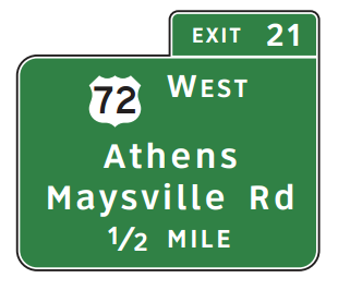
Figure 10: Add “Maysville Rd” to the Exit 21 signage on I-565
The next set of signs are along Memorial Pkwy near the I-565 interchange. The next sign is along the southbound Memorial Pkwy service road before the ramp to westbound I-565.

Figure 11: Oh my goodness! We have to go in two different directions at the same time to reach I-565 west.
I actually didn’t notice this signage error until several years after living here. The problem with this sign is that it indicates that the ramp for I-565 west diverges here, which is not correct. The Exit Only arrow is correct. The ramp diverges in the distance before the overpasses. It is easy to fix this sign: remove the arrow that goes up and to the right from the sign. Or cover it up in green.
Not too far south from this location is another minor, yet confusing signage error. This is immediately before Governors Drive:

Figure 12: Do I exit or do I stay in the lane?
The overhead sign says Exit Only in yellow, which suggests that the lane that I am in exits at that location for Governors Drive. However, as you can clearly see in this picture, the lane continues along Memorial Pkwy southbound. It actually diverges off the parkway at the next exit for Bob Wallace Ave.
I would suggest not only removing the EXIT ONLY part of the sign, but I would also add another sign right beside of it to show the Bob Wallace Ave exit, along with an EXIT ONLY panel and an downward-facing arrow. It would look something like this:

Figure 13: Drop the Exit Only panel off the Governors Drive sign (since the lane doesn’t exit here) and put a sign for the next street, Bob Wallace Ave.
This sort of thing needs to be done along the entire length of the parkway. Upcoming exits aren’t announced until you have almost reached them, which doesn’t give you a lot of time to merge over if needed, especially in rush-hour traffic. Replace the cantilever overhead signs with overhead signs that span all of the lanes, and announce the upcoming exit.
Further south on the parkway, we have this set of signs along Drake Ave going eastbound:

Figure 14: So many highway numbers!
These signs suggest that if you turn left to go north on Memorial Pkwy you will also be on Eastbound US 72 and Southbound US 431. That isn’t exactly the case. You can reach those two routes if you go north here, but this suggests that you can’t reach northbound US 431 or westbound US 72 from here, which isn’t the case.
The solution here is simple. Relace the cardinal directions for US 72 and US 431 with a TO sign.
The next sign is along the Research Park Blvd service road going northbound:

Figure 15: These signs are common along the service roads of the limited access roads in Huntsville.
When these signs were installed, they were accurate. The left lane turned left or U-turned, the middle lane went straight, and the right lane either turns right or goes straight. A few years ago, the City of Huntsville installed a traffic signal at the upcoming intersection. This was done after the westward extension of Oakwood Rd was complete. The middle lane was changed to turn left and go straight when the signal was installed. This sign, however, was not updated to reflect that change. A simple fix would be to replace the middle sign with a sign saying that the middle lane can both turn left and go straight.
The final sign I have for now is along Jordan Lane (Highway 53) going southbound just south of University Drive:

Figure 16: What is the deal with Alternate US 72?
There are no signs anywhere else saying that this route becomes Alternate US 72. This route is signed along the entire length of I-565 to Exit 21. There are no signs that announce the end of it, either. Alternate US 72 and Alabama Highway 20 are sporadically signed all along I-565 at the interchanges, and it is confusing. The signs need to accurately depict what the roads are called. If necessary. truncate Alternate US 72 and Alabama Highway 20 at the I-65 interchange close to Decatur. This would eliminate any confusion.
There are more sign erros around the valley than this. I hope to find and post more of them as I find them!
The problem with the arsenal sign is that to get to the arsenal you have to take 255 S. So you couldn't put the exit for it on the sign for 255 N. They would have to have some distinction for all of 255 to exit and then separate, or two different signs for North and South.
ReplyDeleteThis is a great run down, Cody! I think of this while I'm driving around sometimes and get very thankful that I know where I'm going!
And what further complicates that is that 255 ends right at the entrance to the arsenal, so while you would be on 255 south, it would only be for a few feet before it technically ends.
ReplyDeleteAnother option that may have been better for that sign would be to separate out the AL 255 North/Research Park Blvd sign and then have a separate sign to the right that says Rideout Road South/Redstone Arsenal Gate 9 with an arrow over each lane. You don't have much time once you leave I-565 in which to change lanes if you are in the wrong lane.